Lessons from the 1962 War: there are distinct Tibetan, Chinese and Indian points of view that need to be mutually comprehended (2007)

Prefatory Note: This is part of a series of articles published in The Statesman since October 2007 and republished here, viz., Understanding China, India-USA Interests, China’s India Aggression, Surrender or Fight?, China’s Commonwealth, Nixon & Mao vs India, China’s India Example and China’s Force and Diplomacy. See https://independentindian.com/2009/09/19/my-ten-articles-on-china-tibet-xinjiang-taiwan-in-relation-to-india/


Lessons from the 1962 War

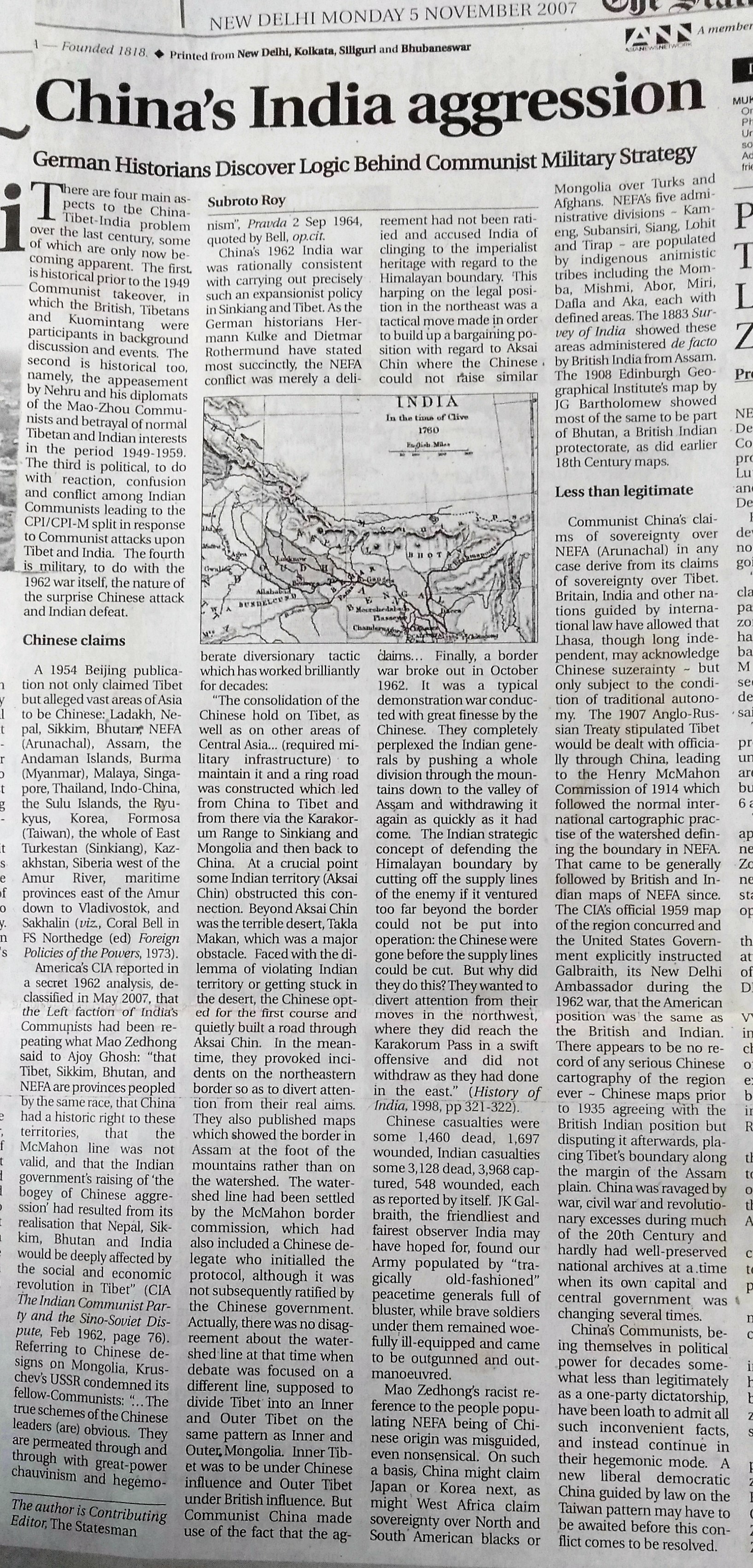
Beginnings of a solution to the long-standing border problem: there are distinct Tibetan, Chinese and Indian points of view that need to be mutually comprehended.

SUBROTO ROY

First published in The Sunday Statesman, January 13 2008,  Editorial Page Special Article

WAR is an existential experience from which nations emerge altered, reflective and sometimes more mature. Germany tried to purge anti-Jewish hatred, Japan to adopt pacifism, Britain to break class-structures, Russia to explode Stalin’s cult. America learnt little from its Vietnam debacle, creating new tactics and technologies to reduce American casualties in war but not showing any improved capacity to comprehend the world beyond its shores and borders.

India after the 1962 defeat by Mao’s China learnt less than was possible and necessary to do. The Government’s official history concluded: “In a fundamental sense, the origins of the 1962 Sino-Indian conflict lay in Chinese expansionism and occupation of Tibet. The issue got further aggravated due to failure of the Chinese to win over the Tibetans. Indian asylum to the Dalai Lama raised Chinese suspicions about ultimate Indian intentions. On the other hand, India, while tacitly accepting the Chinese occupation of Tibet through a treaty in 1954, failed to obtain any quid pro quo on the border issue.” This is true enough but a deeper probe is also possible.

India’s 20th Century political and intellectual leadership may have grossly failed to comprehend critical world events in a realistic manner, specifically Vladimir Ulyanov’s German-assisted Bolshevik coup d’etat, the Kuomintang and Maoist takeovers in China, as well as India’s own struggle for Independence. After BG Tilak, Annie Besant, GK Gokhale and other founders of Indian nationalism passed from the scene, leaders arose like MK Gandhi, MA Jinnah, SC Bose and J Nehru who tended to be consumed, to lesser or greater extent, by their own hubris and were less able to see India’s fortunes and capacities in context of a larger world. None had military, administrative or public finance experience needed for practical government; instead there arose almost a new hereditary caste of the “professional politician” who has no other vocation or anything better to do in life. Nazi-admirers like Mashriqi and Rahmat Ali among Muslims and the Mahasabha and RSS among Hindus also lent mainstream Indian nationalism a harsh distasteful colouration.

Czechoslovakia’s great nationalist Masaryk (who famously denounced Austro-Hungary as a “corrupt, pretentious, senseless relic”) was said to be “a leader who planned further ahead than his contemporaries, understood the corroding effects of power, the vital need of restraint in the ruler, and above all the need for taking the nation into his confidence, educating it in the sense of drawing out all its innate qualities and sharing its manifold aspirations” (Seton-Watson). India’s clear-headed statesmen of that calibre were not among its most visible or ambitious. Vallabhbhai Patel, MAK Azad, C Rajagopalachari and others were left on the sidelines of free India’s politics ~ as Plato predicted, the genuine pilot of the ship of state will be hardly invited to take its wheel nor even want to do so.

Nehru alone, as chosen by Gandhi, came to wield actual power in the 1950s, having maneuvered Rajendra Prasad to being President. And Nehru, besotted in middle age with a married British woman, seemed awestruck by appearance of a victorious Maoist communism in China just as he had been adoring of Stalin’s Russia two decades earlier. The Congress’s friends among India’s official Communists and fellow-travelers never had much original indigenous grassroots support and always looked abroad for guidance. Non-alignment needed to be made of sterner stuff.

Nehru’s flawed management of the relationship with Communist China included not merely choosing a favourite like Krishna Menon to head India’s military, but also imagining himself a competent world diplomatist. Girja Shankar Bajpai would have been far superior as India’s first Foreign Minister. In 1952, Bajpai, then Governor of Bombay, wrote to Nehru saying India should inform Zhou Enlai the McMahon Line was firm in law and non-negotiable.

Was the McMahon Line firm and just? Nehru was no Curzon but it was as a Curzonian imperialist that Mao and Zhou saw him. All Chinese, whether Communist or Nationalist, chafed at the way the Manchu-dynasty’s Empire had been carved up. “China is our India” was Czarist Russia’s intent towards China itself. China had an awful political and military history from when foreign depredations began in the 1840s all the way until the Mao-Zhou era ended in the 1970s. Indeed China’s polity between the 1840s and 1940s suffered far greater chaos and anarchy than India’s in the same period.

From a Chinese standpoint, Younghusband’s diplomatic and military invasion of Gyantze and Lhasa in 1903-1904 was an insult they had been unable to militarily confront. Curzon sent Younghusband’s expedition because there appeared to be Russian intrigues with the Dalai Lama via the Russian/Mongolian agent Dorjiev who had transmitted Russian ideas of extending its new Siberian railway to Lhasa and posting Cossack soldiers there. The Russians seemed to want to adopt the Dalai Lama given his religious influence over Mongolia. The British were alarmed and determined to annihilate the influence of Dorjiev which they did. Thence came the Anglo-Russian Treaty of 1907 which specified British and Russian spheres of influence in Iran and Afghanistan, and stated Tibet would be dealt with internationally only through the Chinese Empire. The McMahon Line, as a recognition of the traditional boundary, flowed naturally from the legitimacy of the Anglo-Russian Treaty. As for Sinkiang, though a Chinese province since 1884 it came to be ruled by warlords under Russian influence.

The Mao-Zhou war machine was determined to take over and militarily hold both Sinkiang and Tibet as an assertion of new China’s self-definition against Russia and Britain; hence their denunciation of Nehru as a pawn first of Britain and then of Russia. China building a road surreptitiously between Sinkiang and Tibet through Aksai Chin was reminiscent of Russia’s coercive behaviour against China in building the Trans-Siberian Railway through Chinese territory to Vladivostok. At worst, the Indians would have to admit that erstwhile J&K State since October 1947 had become an ownerless entity whose unclaimed territory had been carved up by force by the new Pakistan, new India and new China.

From an Indian standpoint, the traditional recognised boundary placed Aksai Chin clearly in Ladakh and not Tibet. Aksai Chain is a salt pit without “a blade of grass” but for all anyone knows, it could be rich in minerals. Karakorum Pass is also newly valuable to the Chinese as they seek to develop a land-route from Baluchistan’s Gwadar Port through Pakistan to China. If India has lost Aksai Chin and Karakorum Pass by force of arms without compensation, force of arms may be the only means of retrieval. Due compensation from China could be Chumbi Valley between Sikkim and Bhutan, and China seems once to have mentioned mutual perpetual lease of Aksai Chin and Chumbi Valley.

From a Tibetan point of view, the Amban representing the Chinese Emperor was driven out of Lhasa in 1912 and Tibet was independent of China for 38 years. Tibet has as much of a claim to be independent of China as Poland or Ukraine have had to be of Russia. As for the McMahon Line, it is indeed legally non-negotiable between China and India as it flowed directly out of the Anglo-Russian Treaty of 1907, and it was under that Treaty that China received international recognition of its formal suzerainty over Tibet since 1720 until that time. Mao once likened Tibet to the palm of a hand with Ladakh, Nepal, Sikkim, Bhutan and Assam as five fingers. Modern China must decide between such a metaphor of Maoist expansionism (which India would have to militarily resist) and joining the world of international law created since Grotius. Democratic conditions in Tibet would also have to be insisted upon so the Dalai Lama and other Tibetans may return home from India in peace and freedom.

Advertisement

Map of India-Tibet-China-Mongolia 1959

This map reproduced from the 1964 edition of Encyclopaedia Britannica is said to have been prepared by the US CIA and is dated 1959.  It is something I published to accompany my November 5 2007 article “China’s India Aggression”.  The Government of India and Government of China have a hard time with maps in discussing the boundary-dispute; this might help them.

See also

https://independentindian.com/2009/06/08/map-of-sinkiangxinjiang-1967-could-this-be-the-best-available-in-the-public-domain/

https://independentindian.com/2008/06/07/map-of-sinkiang-tibet-and-neighbours-1944/

https://independentindian.com/2009/09/19/my-ten-articles-on-china-tibet-xinjiang-taiwan-in-relation-to-india/

China’s India Aggression (2007)

China’s India Aggression

German Historians Discover Logic Behind Communist Military Strategy

by

Subroto Roy

First published in The Statesman, Editorial Page Special Article, Nov 5 2007

There are four main aspects to the China-Tibet-India problem over the last century, some of which are only now becoming apparent. The first is historical prior to the 1949 Communist takeover, in which the British, Tibetans and Kuomintang were participants in background discussion and events. The second is historical too, namely, the appeasement by Nehru and his diplomats of the Mao-Zhou Communists and betrayal of normal Tibetan and Indian interests in the period 1949-1959. The third is political, to do with reaction, confusion and conflict among Indian Communists leading to the CPI/CPI-M split in response to Communist attacks upon Tibet and India. The fourth is military, to do with the 1962 war itself, the nature of the surprise Chinese attack and Indian defeat.

Chinese claims

A 1954 Beijing publication not only claimed Tibet but alleged vast areas of Asia to be Chinese: Ladakh, Nepal, Sikkim, Bhutan, NEFA (Arunachal), Assam, the Andaman Islands, Burma (Myanmar), Malaya, Singapore, Thailand, Indo-China, the Sulu Islands, the Ryukyus, Korea, Formosa (Taiwan), the whole of East Turkestan (Sinkiang), Kazakhstan, Siberia west of the Amur River, maritime provinces east of the Amur down to Vladivostok, and Sakhalin (viz., Coral Bell in FS Northedge (ed) Foreign Policies of the Powers, 1973).

America’s CIA reported in a secret 1962 analysis, declassified in May 2007, that the Left faction of India’s Communists had been repeating what Mao Zedong said to Ajoy Ghosh: “that Tibet, Sikkim, Bhutan, and NEFA are provinces peopled by the same race, that China had a historic right to these territories, that the McMahon line was not valid, and that the Indian government’s raising of ‘the bogey of Chinese aggression’ had resulted from its realisation that Nepal, Sikkim, Bhutan and India would be deeply affected by the social and economic revolution in Tibet” (CIA The Indian Communist Party and the Sino-Soviet Dispute, Feb 1962, page 76). Referring to Chinese designs on Mongolia, Kruschev’s USSR condemned its fellow-Communists: “… The true schemes of the Chinese leaders (are) obvious. They are permeated through and through with great-power chauvinism and hegemonism”, Pravda 2 Sep 1964, quoted by Bell, op.cit.

China’s 1962 India war was rationally consistent with carrying out precisely such an expansionist policy in Sinkiang and Tibet. As the German historians Hermann Kulke and Dietmar Rothermund have stated most succinctly, the NEFA conflict was merely a deliberate diversionary tactic which has worked brilliantly for decades:

“The consolidation of the Chinese hold on Tibet, as well as on other areas of Central Asia… (required military infrastructure) to maintain it and a ring road was constructed which led from China to Tibet and from there via the Karakorum Range to Sinkiang and Mongolia and then back to China. At a crucial point some Indian territory (Aksai Chin) obstructed this connection. Beyond Aksai Chin was the terrible desert, Takla Makan, which was a major obstacle. Faced with the dilemma of violating Indian territory or getting stuck in the desert, the Chinese opted for the first course and quietly built a road through Aksai Chin. In the meantime, they provoked incidents on the northeastern border so as to divert attention from their real aims. They also published maps which showed the border in Assam at the foot of the mountains rather than on the watershed. The watershed line had been settled by the McMahon border commission, which had also included a Chinese delegate who initialled the protocol, although it was not subsequently ratified by the Chinese government. Actually, there was no disagreement about the watershed line at that time when debate was focused on a different line, supposed to divide Tibet into an Inner and Outer Tibet on the same pattern as Inner and Outer Mongolia. Inner Tibet was to be under Chinese influence and Outer Tibet under British influence. But Communist China made use of the fact that the agreement had not been ratified and accused India of clinging to the imperialist heritage with regard to the Himalayan boundary. This harping on the legal position in the northeast was a tactical move made in order to build up a bargaining position with regard to Aksai Chin where the Chinese could not raise similar claims… Finally, a border war broke out in October 1962. It was a typical demonstration war conducted with great finesse by the Chinese. They completely perplexed the Indian generals by pushing a whole division through the mountains down to the valley of Assam and withdrawing it again as quickly as it had come. The Indian strategic concept of defending the Himalayan boundary by cutting off the supply lines of the enemy if it ventured too far beyond the border could not be put into operation: the Chinese were gone before the supply lines could be cut. But why did they do this? They wanted to divert attention from their moves in the northwest, where they did reach the Karakorum Pass in a swift offensive and did not withdraw as they had done in the east.” (History of India, 1998, pp 321-322).

Chinese casualties were some 1,460 dead, 1,697 wounded, Indian casualties some 3,128 dead, 3,968 captured, 548 wounded, each as reported by itself. JK Galbraith, the friendliest and fairest observer India may have hoped for, found our Army populated by “tragically old-fashioned” peacetime generals full of bluster, while brave soldiers under them remained woefully ill-equipped and came to be outgunned and out-manoeuvred.

Mao Zedong’s racist reference to the people populating NEFA being of Chinese origin was misguided, even nonsensical. On such a basis, China might claim Japan or Korea next, as might West Africa claim sovereignty over North and South American blacks or Mongolia over Turks and Afghans. NEFA’s five administrative divisions ~ Kameng, Subansiri, Siang, Lohit and Tirap ~ are populated by indigenous animistic tribes including the Momba, Mishmi, Abor, Miri, Dafla and Aka, each with defined areas. The 1883 Survey of India showed these areas administered de facto by British India from Assam. The 1908 Edinburgh Geographical Institute’s map by JG Bartholomew showed most of the same to be part of Bhutan, a British Indian protectorate, as did earlier 18th Century maps.


Less than legitimate

Communist China’s claims of sovereignty over NEFA (Arunachal) in any case derive from its claims of sovereignty over Tibet. Britain, India and other nations guided by international law have allowed that Lhasa, though long independent, may acknowledge Chinese suzerainty ~ but only subject to the condition of traditional autonomy. The 1907 Anglo-Russian Treaty stipulated Tibet would be dealt with officially through China, leading to the Henry McMahon Commission of 1914 which followed the normal international cartographic practise of the watershed defining the boundary in NEFA. That came to be generally followed by British and Indian maps of NEFA since. The CIA’s official 1959 map of the region concurred and the United States Government explicitly instructed Galbraith, its New Delhi Ambassador during the 1962 war, that the American position was the same as the British and Indian. There appears to be no record of any serious Chinese cartography of the region ever ~ Chinese maps prior to 1935 agreeing with the British Indian position but disputing it afterwards, placing Tibet’s boundary along the margin of the Assam plain. China was ravaged by war, civil war and revolutionary excesses during much of the 20th Century and hardly had well-preserved national archives at a time when its own capital and central government was changing several times.

China’s Communists, being themselves in political power for decades somewhat less than legitimately as a one-party dictatorship, have been loath to admit all such inconvenient facts, and instead continue in their hegemonic mode. A new liberal democratic China guided by law on the Taiwan pattern may have to be awaited before this conflict comes to be resolved.

See also https://independentindian.com/2009/09/19/my-ten-articles-on-china-tibet-xinjiang-taiwan-in-relation-to-india/