How the India-Bangladesh Enclaves Problem Was Jump-Started in 2007 Towards its 2015 Solution: A Case Study of Academic Impact on Policy
by
Subroto Roy, with Brendan Whyte
Progress on the complex problem of India-Bangladesh enclaves started slightly in 1958 and especially 1974, then came to be stalled completely. In May 2007 press reports said a joint delegation was doing some survey work.
That same month, I as Contributing Editor at The Statesman newspaper (biding my time away from a corrupted academia) stumbled on the excellent doctoral work done by a young researcher in Australia on what seemed at the time the impossibly intractable problem of India-Bangladesh enclaves.
I wrote to the newspaper’s Editor on 9 May 2007,
Dear Ravi, You may know that there is an incredibly complex problem between India and Bangladesh relating to enclaves between them, some dating back to Cooch Behar and Mughal enclaves 200 years ago. An Australian researcher named Brendan Whyte at the Univ of Melbourne has done the definitive study of the problem. I think we should invite him to produce a 2000-2500 word two parter on his work which would be very helpful to both governments and to public discussion. If you agree, I can write to him and invite him or you can do so directly. I will have to find his email. Regards Suby
I enclosed a published abstract of Whyte’s work:
“Waiting for the Esquimo: An historical and documentary study of the Cooch Behar enclaves of India and Bangladesh. Whyte, Dr Brendan (2002) “Waiting for the Esquimo: An historical and documentary study of the Cooch Behar enclaves of India and Bangladesh” School of Anthropology, Geography and Environmental Studies, University of Melbourne
“Enclaves are defined as a fragment of one country totally surrounded by one other. A list of the world’s current enclaves and a review of the literature about them reveals a geographical bias that has left enclaves outside western Europe almost untouched. This bias is particularly noticeable in the almost complete absence of information on the Cooch Behar enclaves, along Bangladesh’s northern border with India. The Cooch Behar enclaves number almost 200. This total includes about two dozen counter-enclaves (enclaves within enclaves), and the world’s only counter-counter-enclave. Together, these enclaves represent 80% of the total number of enclaves existing in the world since the 1950s, and have been at the centre of Indo-East Pakistani and then Indo-Bangladeshi boundary disputes since Cooch Behar acceded to India in 1949.
The incredibly complex Cooch Behar sector of the Indo-Bangladesh boundary is investigated in detail for the first time, from historical, political and geographical perspectives. The history of the enclaves is traced, from their origin c.1713 until the present, in an attempt to understand their genesis and survival under a succession of states, from the Kingdom of Cooch Behar and the Mughal Empire in the 1700s, to Bangladesh and the Republic of India today. The difficulties of the enclaves’ existence for their residents and the two countries today is contrasted with their peaceful, albeit administratively inconvenient, existence until 1947, to prove that the enclaves themselves are not the cause of border tensions in the area, but are rather a focus for other cross-border disputes.
The current situation of the enclaves is described, highlighting the abandonment of the enclave residents by each country, which refuse to allow the other to administer its exclaves. India’s inability to implement a 1958 treaty with Pakistan, and its continued delay in ratifying a subsequent 1974 treaty with Bangladesh to exchange the enclaves is highlighted as the major factor impeding resolution of the enclave dispute. That the delays have been rooted in Indian internal politics is demonstrated. Highly disparate official and media reports as to the number, area and population of the enclaves are analysed to determine the true extent of the enclave problem, and the first ever large-scale map of the enclaves is published, locating and naming each enclave.”
The Statesman‘s Editor agreed, and I went about trying to locate Dr Whyte. I think I phoned Australia, asked after him, and learnt he was a New Zealander teaching at a university in Thailand. On 10 May, I wrote to his former department head, Ian Rutherfurd:
Dear Dr Rutherfurd, I am Contributing Editor at The Statesman of Calcutta and New Delhi, and would like to be in touch with your colleague Brendon Whyte but there is no email for him at your site. Please tell him we much wish him to write a two-part article on the editorial page (over two days) for us of less than 2500 words in total on his important research on the India-Bangladesh enclaves. There would be a relatively tiny honorarium probably from the Editor but a large impact on policy and public discussion in both countries. The Statesman is India’s oldest and most eminent newspaper. It may be seen at http://www.thestatesman.net and I am to be found at http://www.independentindian.com Many thanks, Subroto Roy, PhD (Cantab.), BScEcon (London), Contributing Editor
Brendan Whyte replied the same day:
Dear Dr Roy, I have received your message, and am honoured to be asked to write a piece for your paper. I now work in Thailand. Are there any further details regarding this assignment in addition to your information below? For example, is there a deadline, and if so, when? Do you want/can you accept maps/photos and if so how to send them to you? Can the text be sent to you be email or do you prefer a printed version instead of/in addition to an email? Regarding email should the text be in the body of an email or do you prefer an attachment in Word/RTF or other format? Do you prefer a Word document, or should the text be in the body of an email Thank you very much Brendan Whyte, PhD, Faculty of Management Science,Ubon Ratchathani University, THAILAND
I wrote back the same day
Dear Dr Whyte, Many thanks for the quick reply, and our thanks to your colleagues for locating you. The Statesman’s editorial page is as influential a place as there can be in serious Indian public discussion, though I have to say there is far too little such discussion in the country. At my suggestion, the Editor has invited a 2500 word two-part article (over two days); I have said you may have done the definitive work in the area. I know nothing of the subject and am reluctant to suggest any further guidelines, and leave to you to say what you wish once you get a sense of the audience and likely impact. I have in recent months published numerous special articles in The Statesman, and these may be seen at http://www.independentindian.com to give you a sense of the kind of quality you may aim at — though certainly we are a newspaper and not a technical journal. Regarding graphs, each article would have an illustration a few inches square and if you felt you could squeeze the relevant data into two such articles for the two days it would be excellent. Do drop by Calcutta when you can. The honorarium will be a few thousand rupees I expect though the Editor has not specified it yet. No there is no time rush; I accidentally found your work through a wordpress.com blog on strange maps. On second thoughts, if your articles generated invitations from geography departments in India or other invitations to give lectures on the subject, that too would be a worthwhile aim. Best regards Suby Roy
Brendan sent his proposed article a month later in June.
I replied:
Hello, I have reduced it by 300 words without reducing any substance. I hope you may agree. Can you please try to reduce another 200 words, eg of the Belgian/Dutch case? I normally don’t allow anyone to touch my stuff so if you would like to try to reduce it all yourself, that’s fine. Also, 198 is not equal to 106+91+3+1. Please send all the graphics you may think suitable, and people here will try to figure out what to use. It may all go on one day on the Op-Ed page, I have no iodea what the Editor may decide. Also add your PhD University Thanks for this. The work is excellent and I hope it brings you the publicity you deserve. Suby Roy
Brendan sent his final draft on 16 July 2007
Hi Suby, My apologies that this has taken me so long, but the teaching year has been so busy! I have reduced it to 2274 words, about 10% below your limit of 2500. It is attached as a Word file, and appended below as plain text. I hope to send some illustrations separately in the next day or two. Let me know if the revised article is ok or not. Thanks, Brendan
I wrote to the Editor again the same day:
Subject: India-Bangladesh Enclaves: A Major Foreign Policy Problem Solved
Dear Ravi, Apropos our correspondence two months ago, Dr Brendan Whyte has at our request produced an excellent analysis of one of the trickiest and longest-standing problems between India and Bangladesh, viz. enclaves. Dr Whyte is a political geographer from New Zealand who worked on this subject for his doctoral thesis at the University of Melbourne, Australia. He apparently teaches in Thailand at present. By publishing this, we will be doing the MEA a very big favour, besides of course contributing to an important yet neglected public problem relevant to Eastern India. I recommend it for a Saturday night-Sunday night two-parter, rather than the Perspective page, given its close factual basis. Sincerely, Suby.
I wrote to Brendan:
Hello, Your article looks to me first-rate. The basis of a Government White Paper on this side or that. I have forwarded it to the Editor with my recommendation. Please send me any illustrations asap, as he may go with it any day though likely not before the weekend. Best wishes SR
Brendan Whyte’s 16 July 2007 final draft was this:
“The Enclave Problem: India and Bangladesh can and must solve this 300 year problem!
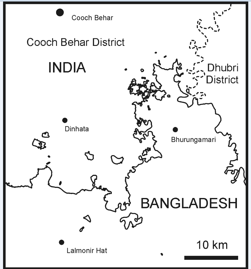
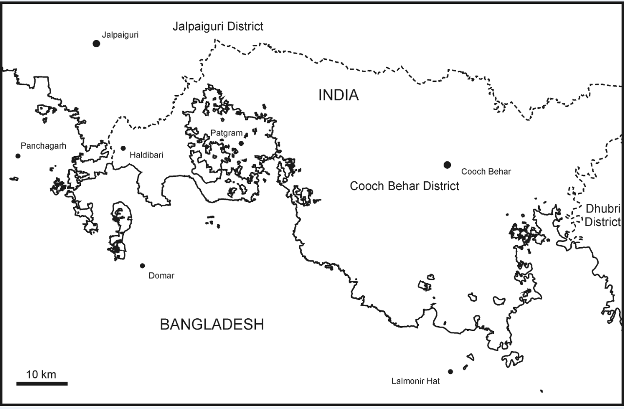
There are 198 “enclaves” (chhit-mahals) between India and Bangladesh. Cooch Behar district has 106 enclaves in Bangladesh, and Bangladesh has 92 enclaves in India: 88 in Cooch Behar, 3 in Jalpaiguri, and 1 between Cooch Behar and Assam’s Dhubri district. The enclaves vary from clusters of villages to individual fields. The smallest Indian enclave may be Panisala, only 0.1093 ha; the smallest Bangladeshi enclave is Upan Chowki Bhajni #24 at 0.2870 ha. The largest are India’s Balapara Khagrabari at 25.95 sq. km, and Bangladesh’s 18.68 sq. km Dahagram-Angarpota. The 198 enclaves also include 3 Indian and 21 Bangladeshi counter-enclaves (enclaves within enclaves). India also possesses the world’s only counter-counter-enclave: a 0.69 ha jute field inside a Bangladeshi enclave inside an Indian enclave inside Bangladesh! Enclave populations-sizes are unknown. The last censuses to include enclaves were in 1951, although the Pakistani enumeration was incomplete. The population today is probably under 100,000 persons in total, 60% living in Indian enclaves in Bangladesh, the rest in Bangladeshi enclaves in India.
The enclaves are 300 years old, originating during the Mughal wars against Cooch Behar in the late 1600s. A treaty was concluded in 1711 in which the Mughals obtained three chaklas from Cooch Behar, but the Subahdar of Bengal rejected the treaty and forced Cooch Behar to cede further lands in 1713, reducing it to about its present borders. This second treaty is the origin of the enclaves: as in feudal Europe, the holdings of kings and their vassals were not contiguous wholes but rather a patchwork of land parcels, so the ceded chaklas included lands inside the unceded areas and vice versa. The East India Company fixed the Bengal-Cooch Behar boundary about 1773, and by 1814 noted that the enclaves were safe havens for bandits. Yet the Company itself created more enclaves in 1817 when it adjudicated a territorial dispute between Cooch Behar and Bhutan, creating Cooch Behari enclaves in then-Bhutanese territory (now Alipar Duar district of Jalpaiguri). These enclaves remained when the British annexed the Bhutanese lands in 1865.
The British quashed the bandit menace but proliferation of liquor, ganja and opium shops in the enclaves became an excise problem between Bengal and Cooch Behar. After discussions, the main boundary of Cooch Behar became the customs and excise boundary. All Cooch Behar enclaves in British India fell under British excise control while all British enclaves in Cooch Behar fell under Cooch Behari excise control. This practical solution to the problem in hand left the sovereignty of the enclaves intact.
A full exchange of enclaves was suggested by the British in the early 1930s, to reduce the costs of the upcoming survey and demarcation of the Cooch Behar boundary but the idea was dropped in face of strong local objections, and all the enclaves were surveyed and demarcated with pillars by the late 1930s.
Partition and independence in 1947, and the subsequent accession of Cooch Behar to India in 1949, elevated the enclaves to the international level. Initially this was unproblematic, with India and Pakistan concluding agreements on cross-border trade and movement in the enclave areas. Censuses in 1951 included the enclaves. But Pakistan’s unilateral 1952 introduction of visas requirements, and immediate Indian reciprocation sealed the fate of the enclave dwellers. High-level politics subordinated the needs of enclave dwellers on both sides.
Full exchange was again agreed upon by the 1958 Nehru-Noon Accord, and this was reiterated in modified form in the 1974 Indira-Mujib Agreement between India and Bangladesh (Bangladesh would keep its largest enclave, Dahagram-Angarpota, to guarantee access to which, India would lease it a short corridor. But a succession of mainly Indian legal challenges regarding the constitutionality of both accords prevented implementation until 1992, when the Tin Bigha corridor was finally opened. The exchange of the remaining enclaves, agreed in 1958 and 1974 and cleared of legal challenged by 1990 remains unimplemented, despite constant Bangladeshi calls for India to implement the agreements fully.
Meanwhile, since the 1950s the chhit mahalis, or enclave dwellers, have been effectively rendered stateless by the two governments abandoning responsibility for them.
India’s fencing of its border with Bangladesh has added a physical dimension to the political isolation of its own enclaves. The chhit mahalis on both sides are unable to vote, to attend schools or markets, to be helped by NGOs working in either country, or to seek police help or medical attention. Each country claims its original citizens have been forced out of their enclaves by the population of the other country surrounding them, and so each country refuses to extend its governmental responsibilities to the supposed invaders. Simultaneously each denies it can legally assist the populations of the other country’s enclaves inside its own territory. Abandoned by both sides, the chhit mahalis struggle to survive without the ability to protect their rights, homes or lives. Bandits once more make use of the enclaves to escape the jurisdiction of the surrounding state.
The problem is one of India and Bangladesh’s own making but it is not unique. Since 1996, when the Lithuanian enclave of Pogiry in Belarus (population: three) was exchanged for equivalent land, 259 enclaves have remained on the world map. Besides India-Bangladesh, there are 61 enclaves affecting 21 countries as owners or hosts. Most consist of a single farm, or a village and its surrounding farmland, inside a neighbouring country. Some approach the complexity of the Cooch Behar enclaves, such as 30 enclaves (including 8 counter-enclaves) belonging to Belgium and the Netherlands in the village of Baarle (population 8500).
The Belgian-Dutch enclaves originated in a feudal agreement c.1198, and emerged at the international level when Belgium declared independence from the Netherlands in 1830. The enclaves were an annoyance to customs, police and foreign ministry officials; but arrangements allowed goods to pass into and through the enclaves, paying tax only if they were destined for the other country or its enclaves. Nevertheless, smuggling brought prosperity to a village on the economic and political periphery of both countries. Today the village park boasts a statue honouring the smugglers. The economic union of Belgium and the Netherlands and the subsequent European Union have eliminated the profitabililty of smuggling without the need for policing or fences. Differences in tax rates and national laws remain, so that some types of business, such as sex or fireworks shops can only operate in one country and its enclaves, and not in the other. Yet the village happily contains both sorts of shops, each in the permitting country, but serving customers from both. Different planning laws, educational syllabii, post offices, town halls, and churches exist side by side. Several businesses and houses straddle the enclave boundaries, enjoying two postal address and two telephone connections. The policemen from each country share an office. The fire departments work together with special hose-coupling devices. Utilities, sewerage, road maintenance and rubbish collection are conducted by one country or he other for the population of both. Where a national law unduly inconveniences the enclaves, an exception is granted. Thus while Sunday shopping is illegal in the Netherlands, the shops in Baarle’s Dutch enclaves may open on Sundays to compete with the Belgian shops, and the village has a thriving Sunday market, drawing crowds from both countries. Before the Euro was introduced, all shopkeepers and government offices accepted both national currencies. Overall the village has boomed as a border market, increasingly tourism-oriented, marketing its enclaves as a tourist attraction. Without the enclaves Baarle would be a small unimportant village. The enclaves have allowed it to surpass its neighbouring villages in size and prosperity.
Other enclaves are often placed inside the customs, postal or telephone jurisdiction of the surrounding country. Switzerland tolerates a casino in the Italian tax-haven enclave of Campione d’Italia, on condition that Swiss citizens have a daily betting limit. Germany’s village of Büsingen, also inside Switzerland, is inside the Swiss customs and currency area, not that of the EU. Passage from the UAE into the Omani enclave of Madha and into the UAE’s counter-enclave of Dahwa inside remain free of controls for locals and foreigners alike. On Cyprus, locals from two villages enclaved inside the British territory (and military base) of Dhekelia move about freely, and farm land under both British and Cypriot sovereignty.
What can India and Bangladesh learn from these foreign enclave cases? They have three main options. The worst is to maintain the status quo, each country refusing to properly govern its own enclaves while also forbidding the other to govern its enclaves across the intervening territory. This “dog-in-the-manger” attitude has reduced the enclaves to poverty and despair, countenanced violence and oppression, fostered corruption, and encourages the problems of criminal dens and drug-cultivation in the enclaves.
The second option is an enclave exchange. Inhabitants should be given two independent options concerning citizenship and relocation. For up to two years after the enclave exchange, they should have the option to choose whether to retain their current citizenship or to become citizens of the other country. They should also have the independent option to remain owning and farming the land they occupy after its tranfer to the other country, or of being resettled on land of equivalent value, size and productive capacity in their original country. There is no reason why they should not be able to choose to stay in situ and retain their old citizenship, nor why they could not hold both citizenships: dual nationality is an increasingly common occurrence worldwide.
The problems with this policy include a requirement for equivalent land for the resettlement of those wishing to relocate, and the need for each country to recognise the inhabitants of its enclaves as its own citizens before exchange. An imbalance in the numbers on each side desiring resettlement will cause difficulties. But it would only repeat the injustices of the 1947 partition if an exchange was made without addressing the needs of the enclave inhabitants, and allowing them some input into the process. The enclaves also form the world’s most complicated boundary, and include the world’s only counter-counter-enclave: so another problem with exchange is heritage loss. Finally, an exchange of enclaves is also an admittance of failure.
Enclave exchange will remove a cartographic anomaly but it will not solve the underlying tensions in bilateral relations. The enclaves are not a problem in themselves but are simply a focus point for distrust and tension created elsewhere. Exchange may not improve the lives of the chhit mahalis, who may end up marginalised, landless and dispossessed by the exchange process. Even if able to remain on their lands, they will still be living in an economically and politically peripheral location. Therefore any exchange should be entered into only with the will of, and in full consultation with, the people involved, so as not to become a further injustice.
A third policy is to retain the enclaves but improve their situation. The 30 enclaves of Belgium and the Netherlands at Baarle, along with other enclaves of Europe and the Middle East, are a good model for this. The advantages are many. It would put the enclave dwellers in charge of their own destiny, leaving them on their lands, but able to engage fully as citizens of their own country.
The distances between each country and its own enclaves are small, often less than one kilometre, rarely more than two or three. Designated access routes, for foot, cart and motorised traffic, could be easily set up and policed. This would allow enclave dwellers to traverse the intervening country to reach the nearest schools and markets of their own country. The local district commissioners should be granted authority to meet frequently and at will to discuss any problems and work out local solutions, without having to refer to New Delhi or Dhaka. Officials such as teachers, doctors, district officials, electoral officers, census enumerators and police should also be permitted visa-free access on demand. Which country’s currency, excise laws, and postal system, electricity and other services are used in an enclave should be based on principles of efficiency, not on chauvinistic nationalism.
There is no reason why exchange of enclaves for customs and excise purposes made in the 1930s could not be readopted. Indian enclaves could be alcohol-free like surrounding Bangladesh, and Bangladeshi enclaves could be prohibited from slaughtering cows as in India. This is no more a threat to the sovereignty of either country than is the differing alcohol and tax regimes of the Indian states and territories. The unique border situation of the enclaves would encourage tourism to this forgotten region in both countries, offering new economic possibilities to an area devoid of industrial capability and development.
India and Bangladesh are not alone in wrestling with the problem of enclaves. Similar problems have been solved in most other enclaves around the world. The long-delayed exchange of the Cooch Behar enclaves, mooted since 1910 and agreed upon in 1958 may simplify the border itself, but it is unlikely to improve bilateral relations, assist economic development of the area or improve the lives of the enclave dwellers. The needs and desires of the chhit-mahalis must be taken into account, but action must be taken to remove their current effective statelessness. The examples of successful enclaves elsewhere in the world suggest that even if relations between two countries are not completely harmonious, enclaves can exist and be beneficial to the economic potential of the area and the prosperity of its inhabitants. These two aspects are the raison d’etre of government, hence it behoves the governments concerned to ensure that any solution to the enclave problem addresses these issues and not merely cartographic simplification, which may only cement the 1947 division more firmly.”
Brendan’s article was published in two parts on Sunday and Monday July 22 2007 & July 23 2007 with very slight alteration –except the splendid maps he had sent failed to be published!
“The Enclave Problem India, Bangladesh can and must solve this 300-year-old issue! By BRENDANWHYTE
There are 198 “enclaves” (chhit-mahals) between India and Bangladesh. Cooch Behar district has 106 enclaves in Bangladesh, and Bangladesh has 92 enclaves in India: 88 in Cooch Behar, 3 in Jalpaiguri, and 1 between Cooch Behar and Assam’s Dhubri district. The enclaves vary from clusters of villages to individual fields. The smallest Indian enclave may be Panisala, only 0.1093 ha; the smallest Bangladeshi enclave is Upan Chowki Bhajni #24 at 0.2870 ha. The largest are India’s Balapara Khagrabari at 25.95 sq. km, and Bangladesh’s 18.68 sq. km Dahagram-Angarpota. The 198 enclaves also include 3 Indian and 21 Bangladeshi counter-enclaves (enclaves within enclaves). India also possesses the world’s only counter-counter-enclave: a 0.69 ha jute field inside a Bangladeshi enclave inside an Indian enclave inside Bangladesh! Enclave population-sizes are unknown. The last census to include enclaves was conducted in 1951, although the Pakistani enumeration was incomplete. The population today is probably under 100,000 in total, 60% living in Indian enclaves in Bangladesh, the rest in Bangladeshi enclaves in India. The enclaves are 300 years old, originating during the Mughal wars against Cooch Behar in the late 1600s. A treaty was concluded in 1711 in which the Mughals obtained three chaklas from Cooch Behar, but the Subahdar of Bengal rejected the treaty and forced Cooch Behar to cede further lands in 1713, reducing it to about its present borders. This second treaty is the origin of the enclaves: as in feudal Europe, the holdings of kings and their vassals were not contiguous wholes but rather a patchwork of land parcels, so the ceded chaklas included lands inside the unceded areas and vice versa. The East India Company fixed the Bengal-Cooch Behar boundary about 1773, and by 1814 noted that the enclaves were safe havens for bandits. Yet the Company itself created more enclaves in 1817 when it adjudicated a territorial dispute between Cooch Behar and Bhutan, creating Cooch Behari enclaves in then-Bhutanese territory (now Alipurduar district of Jalpaiguri). These enclaves remained when the British annexed the Bhutanese lands in 1865. The British quashed the bandit menace but proliferation of liquor, ganja and opium shops in the enclaves became an excise problem between Bengal and Cooch Behar. After discussions, the main boundary of Cooch Behar became the customs and excise boundary. All Cooch Behar enclaves in British India fell under British excise control, while all British enclaves in Cooch Behar fell under Cooch Behari excise control. This practical solution to the problem in hand left the sovereignty of the enclaves intact. A full exchange of enclaves was suggested by the British in the early 1930s, to reduce the costs of the upcoming survey and demarcation of the Cooch Behar boundary but the idea was dropped in face of strong local objections, and all the enclaves were surveyed and demarcated with pillars by the late 1930s. Partition and independence in 1947, and the subsequent accession of Cooch Behar to India in 1949, elevated the enclaves to the international level. Initially this was unproblematic, with India and Pakistan concluding agreements on cross-border trade and movement in the enclave areas. The 1951 census included the enclaves. But Pakistan’s unilateral 1952 introduction of visa requirements, and immediate Indian reciprocation sealed the fate of the enclave dwellers. High-level politics subordinated the needs of enclave dwellers on both sides. Full exchange was again agreed upon by the 1958 Nehru-Noon accord, and this was reiterated in a modified form in the 1974 Indira-Mujib agreement between India and Bangladesh (Bangladesh would keep its largest enclave, Dahagram-Angarpota, to guarantee access to which, India would lease it a short corridor). But a succession of mainly Indian legal challenges regarding the constitutionality of both accords prevented implementation until 1992, when the Tin Bigha corridor was finally opened. The exchange of the remaining enclaves, agreed in 1958 and 1974 and cleared of legal challenges by 1990 remains unimplemented, despite constant Bangladeshi calls for India to implement the agreements fully. Meanwhile, since the 1950s the chhit mahalis, or enclave dwellers, have been effectively rendered stateless by the two governments abandoning responsibility for them. India’s fencing of its border with Bangladesh has added a physical dimension to the political isolation of its own enclaves. The chhit mahalis on both sides are unable to vote, to attend schools or markets, to be helped by NGOs working in either country, or to seek police help or medical attention. Each country claims its original citizens have been forced out of their enclaves by the population of the other country surrounding them, and so each country refuses to extend its governmental responsibilities to the supposed invaders. Simultaneously each denies it can legally assist the populations of the other country’s enclaves inside its own territory. Abandoned by both sides, the chhit mahalis struggle to survive without the ability to protect their rights, homes or lives. Bandits once more make use of the enclaves to escape the jurisdiction of the surrounding state. The problem is one of India and Bangladesh’s own making but it is not unique. Since 1996, when the Lithuanian enclave of Pogiry in Belarus (population: three) was exchanged for equivalent land, 259 enclaves have remained on the world map. Besides India-Bangladesh, there are 61 enclaves affecting 21 countries as owners or hosts. Most consist of a single farm, or a village and its surrounding farmland, inside a neighbouring country. Some approach the complexity of the Cooch Behar enclaves, such as 30 enclaves (including 8 counter-enclaves) belonging to Belgium and the Netherlands in the village of Baarle (population 8500). The Belgian-Dutch enclaves originated in a feudal agreement c.1198, and emerged at the international level when Belgium declared independence from the Netherlands in 1830. The enclaves were an annoyance to customs, police and foreign ministry officials; but arrangements allowed goods to pass into and through the enclaves, paying tax only if they were destined for the other country or its enclaves. Nevertheless, smuggling brought prosperity to a village on the economic and political periphery of both countries. Today the village park boasts a statue honouring the smugglers. The economic union of Belgium and the Netherlands and the subsequent European Union have eliminated the profitabililty of smuggling without the need for policing or fences. Different town halls and churches exist side by side. Several businesses and houses straddle the enclave boundaries, enjoying two postal addresses and two telephone connections. The policemen from each country share an office. The fire departments work together with special hose-coupling devices. Utilities, sewerage, road maintenance and rubbish collection are conducted by one country or the other for the population of both. Where a national law unduly inconveniences the enclaves, an exception is granted. Thus while Sunday shopping is illegal in the Netherlands, the shops in Baarle’s Dutch enclaves may open on Sundays to compete with the Belgian shops, and the village has a thriving Sunday market, drawing crowds from both countries. Before the Euro was introduced, all shopkeepers and government offices accepted both national currencies. Overall the village has boomed as a border market, increasingly tourism-oriented, marketing its enclaves as a tourist attraction. Without the enclaves Baarle would be a small unimportant village. The enclaves have allowed it to surpass its neighbouring villages in size and prosperity. Other enclaves are often placed inside the customs, postal or telephone jurisdiction of the surrounding country. Switzerland tolerates a casino in the Italian tax-haven enclave of Campione d’Italia, on condition that Swiss citizens have a daily betting limit. Germany’s village of Büsingen, also inside Switzerland, is inside the Swiss customs and currency area, not that of the EU. Passage from the UAE into the Omani enclave of Madha and into the UAE’s counter-enclave of Dahwa inside remain free of controls for locals and foreigners alike. On Cyprus, locals from two villages enclaved inside the British territory (and military base) of Dhekelia move about freely, and farm land under both British and Cypriot sovereignty. (To be concluded)
The enclave problem~II What can India and Bangladesh learn from these foreign enclave cases? They have three main options. The worst is to maintain the status quo, each country refusing to properly govern its own enclaves while also forbidding the other to govern its enclaves across the intervening territory. This “dog-in-the-manger” attitude has reduced the enclaves to poverty and despair, countenanced violence and oppression, fostered corruption, and encouraged the problems of criminal dens and drug-cultivation in the enclaves. The second option is an enclave exchange. Inhabitants should be given two independent options concerning citizenship and relocation. For up to two years after the enclave exchange, they should have the option to choose whether to retain their current citizenship or to become citizens of the other country. They should also have the independent option to remain owning and farming the land they occupy after its transfer to the other country, or of being resettled on land of equivalent value, size and productive capacity in their original country.
Dual nationality There is no reason why they should not be able to choose to stay in situ and retain their old citizenship, nor why they could not hold both citizenships: dual nationality is an increasingly common occurrence worldwide. The problems with this policy include a requirement for equivalent land for the resettlement of those wishing to relocate, and the need for each country to recognise the inhabitants of its enclaves as its own citizens before exchange. An imbalance in the numbers on each side desiring resettlement will cause difficulties. But it would only repeat the injustices of the 1947 Partition if an exchange was made without addressing the needs of the enclave inhabitants, and allowing them some input into the process. The enclaves also form the world’s most complicated boundary, and include the world’s only counter-counter-enclave: so another problem with exchange is heritage loss. Finally, an exchange of enclaves is also an admittance of failure. Enclave exchange will remove a cartographic anomaly but it will not solve the underlying tensions in bilateral relations. The enclaves are not a problem in themselves but are simply a focus point for distrust and tension created elsewhere. Exchange may not improve the lives of the chhit mahalis, who may end up marginalised, landless and dispossessed by the exchange process. Even if able to remain on their lands, they will still be living in an economically and politically peripheral location. Therefore any exchange should be entered into only with the will of, and in full consultation with, the people involved, so as not to become a further injustice. A third policy is to retain the enclaves but improve their situation. The 30 enclaves of Belgium and the Netherlands at Baarle, along with other enclaves of Europe and the Middle East, are a good model for this. The advantages are many. It would put the enclave dwellers in charge of their own destiny, leaving them on their lands, but able to engage fully as citizens of their own country. The distances between each country and its own enclaves are small, often less than one kilometre, rarely more than two or three. Designated access routes, for foot, cart and motorised traffic, could be easily set up and policed. This would allow enclave dwellers to traverse the intervening country to reach the nearest schools and markets of their own country. The local district commissioners should be granted authority to meet frequently and at will to discuss any problems and work out local solutions, without having to refer to New Delhi or Dhaka. Officials such as teachers, doctors, district officials, electoral officers, census enumerators and police should also be permitted visa-free access on demand. Which country’s currency, excise laws, and postal system, electricity and other services are used in an enclave should be based on principles of efficiency, not on chauvanistic nationalism. There is no reason why exchange of enclaves for customs and excise purposes made in the 1930s could not be readopted. Indian enclaves could be alcohol-free like surrounding Bangladesh, and Bangladeshi enclaves could be prohibited from slaughtering cows as in India. This is no more a threat to the sovereignty of either country than is the differing alcohol and tax regimes of the Indian states and territories. The unique border situation of the enclaves would encourage tourism to this forgotten region in both countries, offering new economic possibilities to an area devoid of industrial capability and development.
Economic potential
India and Bangladesh are not alone in wrestling with the problem of enclaves. Similar problems have been solved in most other enclaves around the world. The long-delayed exchange of the Cooch Behar enclaves, mooted since 1910 and agreed upon in 1958 may simplify the border itself, but it is unlikely to improve bilateral relations, assist economic development of the area or improve the lives of the enclave dwellers. The needs and desires of the chhit-mahalis must be taken into account, but action must be taken to remove their current effective statelessness. The examples of successful enclaves elsewhere in the world suggest that even if relations between two countries are not completely harmonious, enclaves can exist and be beneficial to the economic potential of the area and the prosperity of its inhabitants. These two aspects are the raison d’etre of government, hence it behooves the governments concerned to ensure that any solution to the enclave problem addresses these issues and not merely cartographic simplification, which may only cement the 1947 division more firmly.
(Concluded)”
I wrote to him immediately Hello, You were published in yesterday’s Sunday Statesman and continued in this morning’s edition, as the special article on the editorial page. I am enclosing the text as it appears on the Internet edition. Through some apparent editorial mishap, the illustrattions you sent never got published, and two photographs were used. I think you could follow it up with an invited talk in Kolkata. If you wish, I can look into that possibility. Send me a cv if you are interested and I shall see what I can do. Re working with me on the China-India problem, a visit from you might enable us to talk further. I am introducing you separately to the Editor’s assistant who should help with copies, money etc. Best wishes Subroto Roy
All that was between May and July 2007.
On 6 September 2011, Dr Manmohan Singh as India’s PM on a visit to Bangladesh apparently signed what the India’s Foreign Ministry calls the “2011 Protocol”. And now a few days ago, Prime Minister Sheik Hasina, Prime Minister Narendra Modi, along with the agreement of Chief Minister Mamata Banerjee, have all signed a comprehensive landmark “Land Boundary Agreement” between India and Bangladesh, solving the 300 year problem! All’s well that ends well…
And yes, Excellencies, PM Sheikha Hasina, PM Narendra Modi, former PM Manmohan Singh, CM Mamata Banerjee: re the Land Boundary Agreement, Dr Brendan Whyte and I and The Statesman newspaper may all take a bow after you…
Nota Bene: The Statesman for some reason did not publish along with Dr Whyte’s excellent article these important maps which are now published here below for the first time: